The great landslide of Assapaat in June 2021 on the Nuussuaq Peninsula in West Greenland, is a result of thawing permafrost. This is shown in a recent study involving APRI researcher Daniel Binder of the Geological Survey of Denmark and Greenland (GEUS).
The large landslide in the form of a frozen debris avalanche occurred on June 13, 2021, at 04:04 a.m. local time in West Greenland on the southern coast of the Nuussuaq Peninsula near Assapaat, opposite Disko Island.
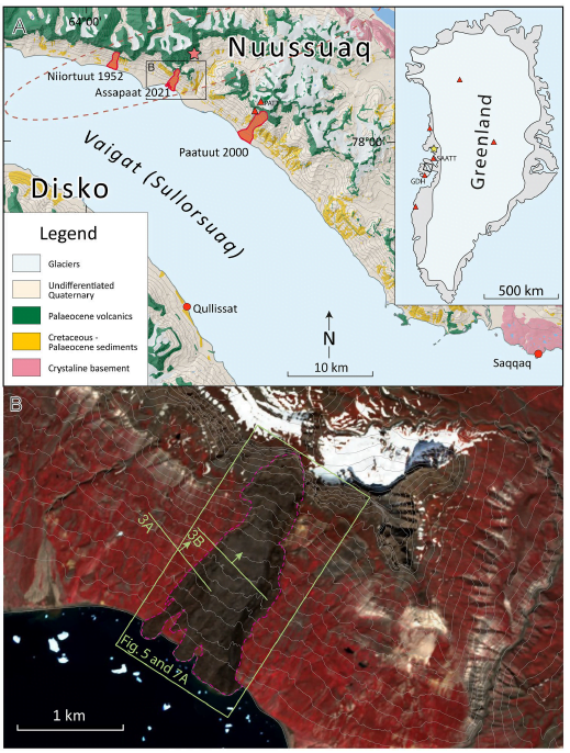
Location of the landslide event and historical landslides in Vaigat (red polygons) shown on a simplified scale geological map.
Background
Records of landslides in the polar regions are incomplete due to these areas’ remoteness and sparse population. In recent years, efforts have been made to research historical landslides on the one hand and to completely record landslides from the present time on the other hand. Data gaps on the deformation and failure of mountain slopes could be closed by analyzing current and historical events. Especially the effects of climate change are impressively reflected in landslides caused by thawing permafrost. Permafrost is said to occur when the temperature of the ground is below zero degrees Celsius for at least two consecutive years. These are conditions that are also found in the high alpine regions. The present climate in West Greenland is arctic. Therefore, permafrost soils are found here, although especially the situation in slope areas, which have a different angle of solar radiation, is still little explored. The recording and especially the more detailed research of the landslide processes and the underlying causes are of great importance for the safety of the Greenlandic population and course for climate research.
Also not far from the studied landslide, there were two other landslide events in the near past, but they are less precisely described.
Consequences
One of the hazards associated with landslides is the possible devastation of settlements by the earth and rock masses or by tsunami-like water waves caused by the sudden sliding of debris and mud into the sea.
The studied slopes along the Vaigat Strait between Nuussuaq and Disko Island represent a high-risk area for such tsunami-induced landslides. Landslides of greater magnitude have been documented in 1952 and 2001. In 2021, an even much larger landslide occurred. The area was very well documented from a helicopter two years earlier using photographs, and the first cracks were also observed. The publication describes the detailed events from field observations, photos, remote sensing, and seismic monitoring data.
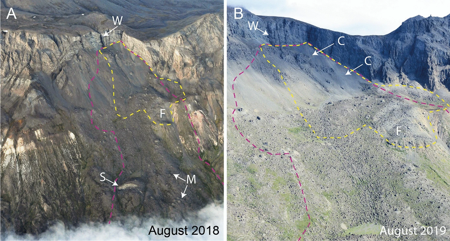
Pre-failure photos of the scar area
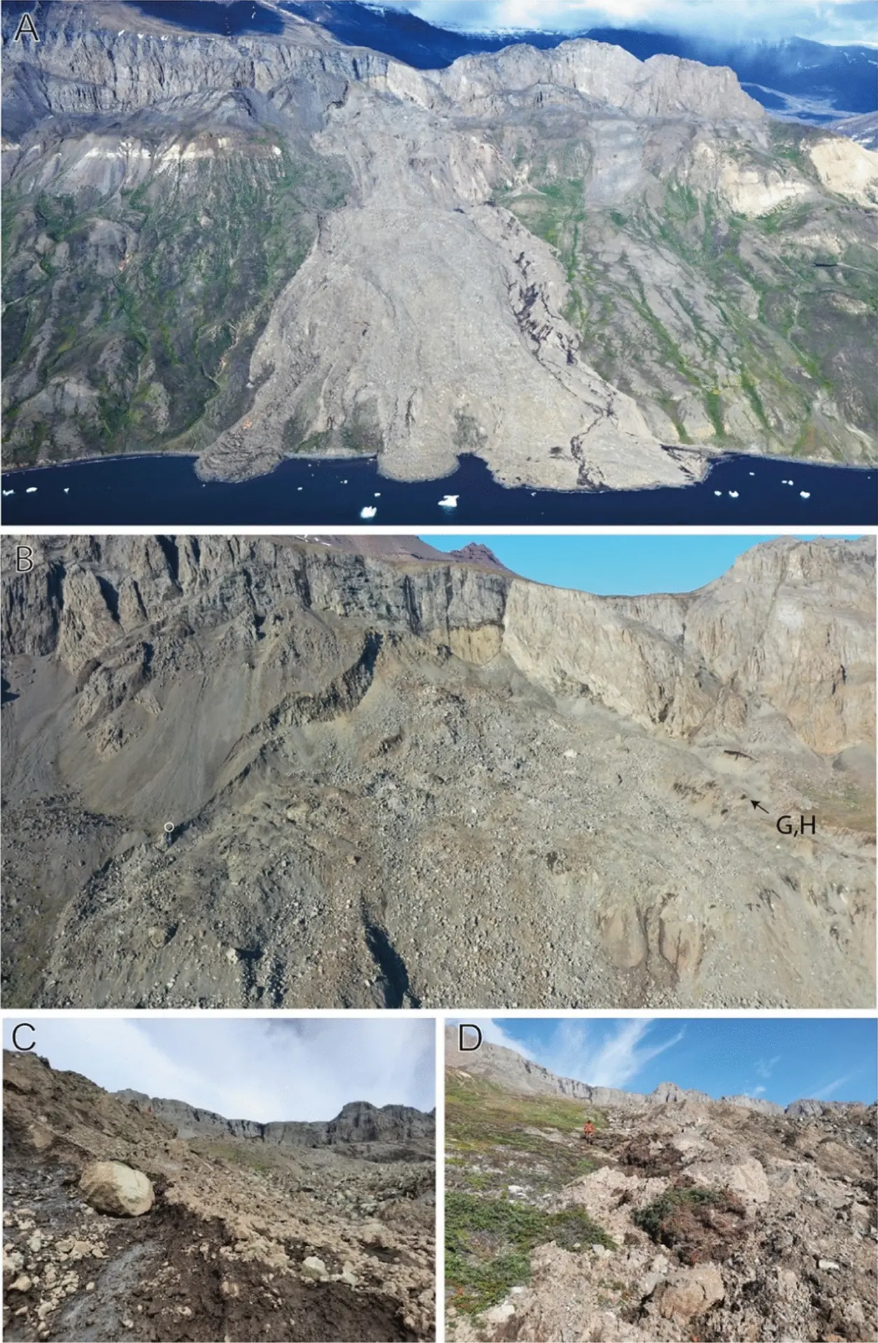
Photos of the landslide from different positions
Results
Analyzing the collected data in combination with a digital elevation model before and after the landslide provides an accurate description of this type of landslide for the first time. An illustrative model of landslide development is shown in the following figure.
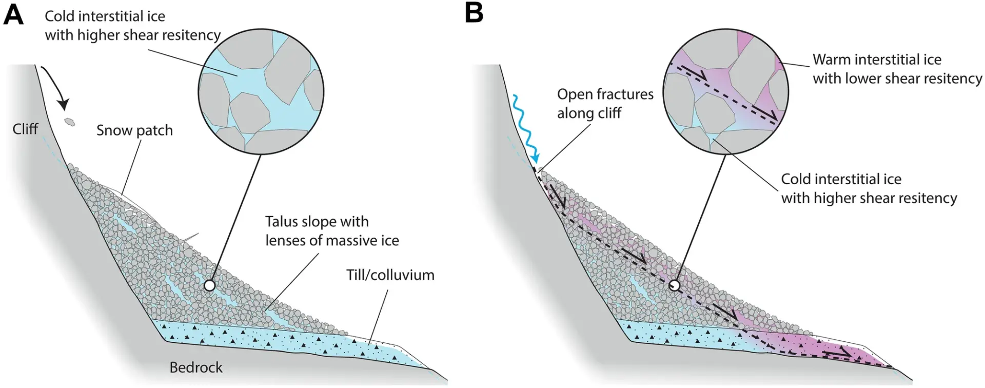
Illustrative model of the landslide development
The frozen debris avalanche started with the breakdown of a permafrost debris slope (6.9 million m3) and the underlying boulder clay, so-called colluvium at 600-880 m altitude.
Background info: Colluvium (lat,: the washed together): Loose sediments consisting of mostly clayey or sandy soil material rearranged by alluvium, which can form layers up to several decimeters thick.
The photos of the landslide clearly show the cracking. Similar to a snow slab, a volume ranging from 18.3 million to 25.9 million m3 ruptured along its 2.4 km long path, taking with it two successive landslides. Approximately 3.9 million m3 is estimated to have departed into the Vaigat Strait. Surprisingly, however, no tsunami was reported. This is probably because, in the second phase of the event, the partially frozen debris avalanche lost velocity due to a flattening of the slope. The study hypothesizes that during the slide, the warming of the permafrost matrix causes the slide to be very dynamic. When the temperature of the ice in the permafrost bedrock increases to a critical level, the shear resistance decreases. This leads to an unstable condition and, subsequently, to the collapse of the inclined debris slope. It can be concluded that the continuing warming of the Arctic will lead to an increase in such landslides.
Outlook
To test the hypothesis, it is necessary to collect further data such as precipitation, snowmelt, soil, and surface temperature. It is therefore important that research funds continue to be made available in the future to better predict the change in landslide risk in the Arctic. In addition, cooperation with research projects from the alpine area is important, since comparable problems are pending here and situations with related conditions can lead to a deeper understanding.
Media information
Written by Barbara Hinterstoisser, member of the APRI-Media Team.
Layout and English translations by APRI-Media Team.
Contact: use our contact form.
Photos from the original publications.
Header photo Kristian Svennevig/GEUS.
About the scientific authors
Daniel Binder, University of Potsdam, ZAMG, GEUS, APRI research group Greilinger.
Access to the original paper.